
- Search
- Outside Resources
- Commute Options Information
- Contact Us / Get Involved
- Español
- Civil Rights / Title VI
- Newsletter
- Webinars
100 State St.,
Suite 400
Madison, WI 53703
Contact:
Tel: (608) 266-4336
Email: MPO
Hours:
Monday - Friday
8:00am to 4:30pm
MPO employees are working remotely part-time. For this reason, please contact staff before visiting the office in person.
Dane County Bicycle Map
The Dane County Map for Bicyclists is a cooperative effort by The Greater Madison MPO, The City of Madison, and Dane County.
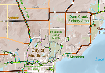
The Dane County Bicycle Map is designed to assist bicycle riders in identifying the safest, most enjoyable routes for their trip.
The map depicts the relative condition of rural roadways (i.e., generally speed limit of 45 mph or higher) in the county for riding a bicycle. The bicycle suitability ratings are intended for use by adults who have had drivers’ education and possess the skills and knowledge to handle shared bicycle / motor vehicle situations.
The Dane County Bicycle Map online:
Dane County Bicycle Map Application for viewing in a web browser.
Dane County Bicycle Web Map that can be customized in ArcGIS.com.
Low-Stress Bike Route Finder can be used to find urban street routes based on comfort levels. Bicycling conditions for roadways in urban areas are not shown on The Dane County Bicycle Map.
Story Map of Featured Bicycle and Pedestrian Trails in Dane County.
Bicycle maps for the City of Madison and other areas in Dane County are available here:
Maps For Bicyclists.
PDFs of The Dane County Bicycle Map:
Madison Area (Front Side)
(Reduced PDF) (2 MB)
(High Resolution PDF) (27 MB)
Dane County (Back Side)
(Reduced PDF) (3 MB)
(High Resolution PDF) (87 MB)
Additional Bicycling Related Information